This restoration shows an abandoned residence & car, one of the last buildings that remained standing in the once-thriving company town of Bradwood, Oregon as seen in April 1981.
The town was the company town of the Bradley-Woodward Lumber Company, and was incorporated in July 1930. It’s name was a derivative of the company name. Shortly after the mill began operations, work began on creating the town.
Bradwood was a location on the Columbia River situated between the towns of Knappa & Wauna, Oregon, about 22 miles east of Astoria.
With a shipping port and served by the SP&S railroad, Bradwood became the terminus for the company’s private railroad bringing down logs felled on Nicolai Mountain, milling them at the company mill & shipping finished products out by ship & rail. Lumber from the mill was used to construct the houses & businesses that were built to accommodate the millworkers & their families.
The mill and town thrived during the depression years and throughout World War II but afterward the once abundant timber stands dwindled and the mill ceased operations of it’s privately owned logging railroad. The mill continued on in operations with logs brought in by trucks & purchased log rafts for awhile. At some point, the entire operation was sold to Pope & Talbot Co.
In June 1962 the decision was made to close down the mill and a year later, on June 25th, 1963 the mill & entire town was sold at auction into private hands. Some of the buildings were moved or deconstructed but the rest were simply abandoned.
A major fire in 1965 destroyed the mill & much of the remaining buildings, and another fire in 1984 took care of what buildings remained including the house pictured here.
Today, the property is privately held, no structures or roads remain, and there is no evidence that the little community of Bradwood ever existed. In the mid-2000s, the site was considered for a proposed terminal for receiving liquefied natural gas (LNG). Protests & bankruptcies however derailed that plan and today the site is unimproved with posted “No Trespassing” signs.
This restoration shows the Bradwood Store, one of the last buildings that remained standing in the once-thriving company town of Bradwood, Oregon as seen in April 1981.
The town was the company town of the Bradley-Woodward Lumber Company, incorporated in July 1930. It’s name was a derivative of the company name. Shortly after the mill began operations, work began on creating the town.
Bradwood was a location on the Columbia River situated between the towns of Knappa & Wauna, Oregon, about 22 miles east of Astoria.
With a shipping port and served by the SP&S railroad, Bradwood became the terminus for the company’s private railroad bringing down logs felled on Nicolai Mountain, milling them at the company mill & shipping finished products out by ship & rail. Lumber from the mill was used to construct the houses & businesses that were built to accommodate the millworkers & their families.
The mill and town thrived during the depression years and throughout World War II but afterward the once abundant timber stands dwindled and the mill ceased operations of it’s privately owned railroad. The mill continued on in operations with logs brought in by trucks & purchased log rafts for awhile. At some point, the operation was sold to Pope & Talbot Co.
In June 1962 a decision was made to close down the mill and a year later, on June 25th, 1963 the mill & entire town was sold at auction into private hands. Some of the buildings were moved or deconstructed but the rest were abandoned.
A major fire in 1965 destroyed the mill & much of the remaining buildings, and another fire in 1984 took care of what buildings remained including the Bradwood Store.
Today, the property is privately held, no structures or roads remain, and there is no evidence that the little town of Bradwood ever existed. In the mid-2000s, the site was considered for a proposed terminal for receiving liquefied natural gas (LNG). Protests & bankruptcies however derailed that plan and today the site is unimproved with posted “No Trespassing” signs.
This restoration from the original photo shows the engine & crew of the Astoria & Columbia River Railroad’s Engine No. 4 at Astoria or Seaside, OR in 1904.
The history of the short-lived Astoria & Columbia River Railroad is given below:
By late summer 1883, the Northern Pacific (NP) had completed a route to Portland, Oregon, and was the first railroad to open the Pacific Northwest to transcontinental trade. Without a bridge across the Columbia River at the time, the NP used car ferry service between Kalama, Washington, and Goble, Oregon, to access Portland. The first saw trains arrive in autumn 1883. Curiously, despite Astoria’s status as an important port town near the mouth of the Columbia and Pacific Ocean, and only 50 miles from Goble, the NP made no attempt to lay tracks there. Desperately wanting rail service to their town, the city formed the Astoria & South Coast Railway (A&SC) in August 1888. The new railroad was chartered to run south along the coast and then turn southeasterly to Hillsboro.
By the summer of 1890, the A&SC was completed to Seaside, 15 miles south, which opened for service the following summer. However, the company fell into bankruptcy in February 1892 and was reorganized as the Astoria & Portland Railway (A&P). This new system was also projected to reach Hillsboro but via slightly a different route that would pass through the rugged Coast Range. Ultimately, this idea fell through due to lack of funding, and so the railroad remained stuck with its original 15-mile line and no solid plans to complete an outside connection.
During May 1893, the A&P was sold to the newly formed Seashore Road Company.
In 1895, the Astoria & Columbia River Railroad was incorporated for construction with a connection between Astoria and the Northern Pacific. A construction company was contracted to perform construction, and despite the fact that A&CR did not own the Seashore Road Company, the contractor invested in improvements to the line, including work on a new bridge to connect the existing railroad with Astoria, and a line northward on the west side of Young’s Bay to Fort Stevens and the area that would eventually become known as Warrenton.
In 1896, the Seashore Railroad Company started operating trains over a new bridge across Young’s Bay, connecting Astoria to Seaside directly.
In 1897, the owners of the Astoria & Columbia River Railroad purchased the Seashore Railroad Company & it was absorbed into the Astoria & Columbia River Railroad (A&CR). This new company, under the direction of A.B. Hammond, abandoned the proposal to reach Hillsboro and instead looked eastward to build a line along the Columbia River and a connection with the Northern Pacific at Goble.
A ceremony celebrating the opening of the link between Astoria and the Northern Pacific was held on April 4, 1898, but the first train from Portland did not operate over the line until May 16. Some 700 people rode the train to celebrate the completion.
In 1899, the last stage of the lines northwest from Astoria were completed, and the line was able to operate all the way to Fort Stevens.
In 1907, a short branch was built south of Seaside to Holladay. Here, a wye was built for turning the trains, and a connection to a logging railroad was also eventually made. In all, the A&CR operated 118 miles of main line from Portland to Seaside and an additional 2.7 miles along its spur to Hammond. Freight traffic predominantly consisted of timber products (logs and finished lumber) as well as canned fish and seafood products from the port. Passenger service to Seaside was incredibly popular. Beginning in the late 1870s with the construction of the resort hotel Seaside House, and through the early 20th century, the coastal town of Seaside was a popular destination that saw thousands of vacationers during the summer and the creation of the “Daddy Trains,” weekend trains that reunited workers that sought work in Portland with their families that still lived in the Seaside area. Tapping into this, the railroad promoted the route with pamphlets claiming “The Oregon Coast: From Portland to Summer Paradise in Four Hours.”
In 1907, with the railroad popular & profitable, Hammond sold his railroad to James Hill, owner of the Great Northern Railway.
Hill continued to operate the railroad under the A&CR name until 1911, when the operation of the Astoria line was slowly converted to the Spokane Portland & Seattle (SP&S) name (also controlled by Hill interests). The A&CR name did not disappear at once, but was simply slowly dropped from paperwork and other documents, as well as rolling stock.
For the next 6 decades, the SP&S continued to operate the former A&CR lines until everything came under the Burlington Northern “umbrella ” in 1970, following a merger of the SP&S; NP; GN; Chicago, Burlington & Quincy; and a myriad of other, smaller “paper” railroads, such as the A&CR. The BN used the line to Astoria until 1978 when much of the route was abandoned.
The SP&S ceased passenger service to Seaside in 1952 but maintained freight service until the late 1960s. Following the Burlington Northern merger and abandonment of the line west of Astoria, the decision was made in the late 1980’s by the railroad to remove all tracks, ties & structures west of Astoria.
In the early 1990’s, the Burlington Northern also wanted to get rid of the line into Astoria due to high property taxes and little traffic. Astoria, however wanted the line retained so, after negotiations with the railroad, the city obtained the line, and today operates its city trolley over it.
This restoration shows a surfboat bringing supplies out to the Tillamook Rock Lighthouse, perched on top of basalt rock in the Pacific Ocean, about 1.3 miles out from shore between Seaside & Cannon Beach, Oregon circa 1890.
An intriguing and powerful testament of the will and determination of the human spirit, the story of Tillamook Rock Lighthouse began in 1878 when Congress appropriated $50,000 for a lighthouse to mark this section of the Oregon Coast. Originally, it was hoped that a lighthouse could be built at Tillamook Head, a 1,000-foot-high headland twenty miles south of the Columbia River, however, the top of the headland was often shrouded in fog, and as its sheer face offered no acceptable alternative, Tillamook Rock was chosen instead.
Congress, after being apprised that “Tilly’s” preliminary survey indicated that far more work & money would be needed, ordered a second and this time, complete survey in September 1879. It was led by John Trewavas, whose resume included Wolf Rock lighthouse in England. As Trewavas attempted to climb onto the rock from the surfboat, he slipped and fell into the churning water. A sailor in the surfboat jumped in to rescue the surveyor but was unsuccessful & he was pulled from the water by the surfboat crew. Trewavas was not seen again & his body was never recovered.
On October 21, 1879, the first four workmen finally landed on the rock with supplies and a temporary shelter. The remaining five members of the crew followed five days later. The remaining supplies and personnel were transported to the rock by means of a line run from the mast of the US Revenue Cutter Thomas Corwin to the rock. A breeches buoy – essentially a pair of pants within a life ring – was used to transport men to and from the rock across the line. This worked well as long as the line remained taut – if the seas caused the ship to pitch, the slack line could deposit the occupant of the breeches buoy into the ocean.
The first ten days found the crew totally exposed to the elements. Barren of caves, overhangs, or ledges, the rock could not even provide minimal shelter. A shallow niche was excavated in the northeast side of the rock, and in it was placed a strongly built timber shanty that was securely bolted to the rock and covered in canvas. With shelter in place, the men leveled a site for a derrick, and then commenced chiseling, and blasting away the upper thirty feet of the rock to create a site for the lighthouse at a height of ninety feet above the sea.
Amidst miserable working conditions, the workers succeeded in blasting the top of the rock by May 1880. A large derrick was built for transporting men, supplies and building materials, including the stone for constructing the lighthouse.
January 2, 1880, brought a heavy storm with seas crashing above the crest of the rock. Rocks flew as breakers tore off chunks of the rock and tossed them randomly. The perilous storm pounded the rock, sweeping away a storehouse along with tools and provisions. Next, the water tank, the traveler line, and the roof of the blacksmith shop were ripped away. Hungry, soaked, and with no place to go, the men hunkered down in their shelter, the safest place on the rock.
The tower was first lit on January 21, 1881. The lighthouse came at a final cost of $125,000. The 62-foot tower displayed a first-order Fresnel lens 133 feet above sea level. The keepers were housed in the large square base of the tower. The station was also equipped with a fog signal and four keepers were assigned to the station.
The importance of the lighthouse tragically presented itself three weeks before the light was lit. On a stormy & foggy January 2, 1881 night, the lighthouse was nearly complete but not yet lit. At 8PM, workers at the lighthouse heard & then observed a vessel approaching the rock. They hurriedly lit bonfires to warn the approaching ship and the ship veered off and disappeared into the night. The next morning, the workers spotted the wreck of the squarerigged British bark Lupatia, enroute to Portland from Hiogo, Japan. The ship had missed Tillamook Rock but sailed directly into Tillamook Head. When dawn broke, the workers could see the broken mizzen topmast of the ship jutting from the sea. Searchers later found five of the crew dead in a rocky cove near the cliff. Seven more of the Lupatia’s crew were found deceased about a half mile further down the beach. Four more of the crew were never found. All sixteen of her crew perished – only the ship’s Australian Shepard dog survived and was taken to a friend of the ship’s captain in Astoria. The twelve recovered seamen were carried a mile & a half inland and buried.
Duty at Tillamook was difficult at best. The station had four head keepers in the first two years. The keepers were completely isolated on the rock, yet could see the lights of the nearby towns offshore. Storms pounded the lighthouse. An 1897 storm cut a newly installed telephone cable to the lighthouse. 100 tons of rock was shorn off the western end of the rock in a 1912 storm. Windows were gradually cemented over, replaced by small portholes. The wild seas & storms combined with the lighthouse’s isolation brought her well-known nickname “Terrible Tilly.”
October 21, 1934 brought the worst tempest ever recorded at the lighthouse and it was seriously damaged by the severe storm. Winds reached 109 miles per hour. Huge boulders were thrust into the lighthouse, smashing the lantern room and the lens and iron bolts anchored three feet deep in the rock were ripped out .
The ferocity of the storm was recounted in the Lighthouse Service Bulletin & presented here:
“Repeatedly the entire station was completely submerged in tremendous seas which, meeting the precipitous side of the great rock, swept upward and over the masonry and ironwork structure surmounting the crest. A section of the rock itself was torn away, great fragments of it being thrown over the station, many of them through the plate glass of the first order lantern, 16 panels of which were shattered, rock fragments 60 pounds in weight falling inside. Unbroken seas flooded the lantern, filling the watch room, where the keepers struggled to erect storm shutters in the shattered lantern panels, submerged at times to their necks before the rush of water could escape through the door into the tower and quarters below. The inrushing seas brought fragments of rock and glass, and even small fish, with the flotsam. Assistant Keeper Hugo Hanson’s hand was badly cut with flying glass.
The oil vapor light was extinguished, the first order lens chipped and cracked, and the revolving mechanism so badly damaged that it was not repaired and operated until 6 days later. No light was displayed that first night, but the keepers succeeded during the night and the next day in clamping heavy wooden shutters, on hand for the purpose, into the lantern panels from which the glass panes had been broken, and thereafter displayed a fixed white light from a 300-millimeter lens lantern until the main light was repaired and its regular flashes restored on October 27. The storm raged for 4 days; the great seas thundering over the rock, preventing the keepers from leaving the confines of the tower and quarters until October 25.”
The storm severed the telephone line linking the station to the mainland, but Assistant Keeper Henry Jenkins, an amateur radio operator, cannibalized the telephone and used waxed paper, tin foil, and brass doorknob plates to create a makeshift short wave radio. Around midnight on October 23, he managed to relay a message to the lighthouse superintendent, apprising him of conditions at the station. All four keepers on the rock were later commended for their exceptional attention to duty through the most trying conditions.
The station survived, but repairs cost $12,000 and it was not completely repaired until February 1935. The Fresnel lens was replaced by an aerobeacon, and a metal mesh placed around the lantern room to protect the tower from large boulders.
Tillamook Rock shone it’s guiding light for 77 years but was extremely expensive to maintain. When the Coast Guard began automating stations, Tillamook Light was replaced by a red whistle buoy a mile seaward. The last keeper, Oswald Allik, switched off the light on September 1, 1957. Allik, who had served twenty years at the station, penned the following final entry in the logbook, which today is on display at the Columbia River Maritime Museum in Astoria, Oregon:
“Farewell, Tillamook Rock Light Station. An era has ended. With this final entry, and not without sentiment, I return thee to the elements. You, one of the most notorious and yet fascinating of the sea-swept sentinels in the world; long the friend of the tempest-tossed mariner. Through howling gale, thick fog and driving rain your beacon has been a star of hope and your foghorn a voice of encouragement. May the elements of nature be kind to you. For 77 years you have beamed your light across desolate acres of ocean. Keepers have come and gone; men lived and died; but you were faithful to the end. May your sunset years be good years. Your purpose is now only a symbol, but the lives you have saved and the service you have rendered are worthy of the highest respect. A protector of life and property to all, may old-timers, newcomers and travelers along the way pause from the shore in memory of your humanitarian role.”
Since Tilly’s decommissioning, the lighthouse has been bought & sold several times. In 1980, it was sold to real estate developers Mimi Morissette and Cathy Riley, backed by a group of investors.
Under Morissette’s direction, the structure was gutted and turned into the Eternity at Sea Columbarium. Interested parties could have their ashes placed inside the lighthouse, with prices varying from $1,000 for a place in the derrick room to $5,000 for a prime spot in the lantern room. The owners of the lighthouse lost their license to operate as a columbarium in 1999 when they were late with their renewal. In 2005, an application for a new license was rejected due to inaccurate record keeping and improper storage of urns. Eternity at Sea still plans to raise additional money and construct niches in titanium to store some 300,000 urns.
Efforts & fundraising are still ongoing for repairs & restoration of Tillamook Rock Lighthouse. She was listed on the National Register of Historic Places on December 9, 1981.
This restoration from the original iconic print by Frank Woodside shows a view of the shore at Seaside, Oregon just north of Oceanway street from an elevated spot on the Pacific Pier in 1914. On the extreme right side of the photo is a glimpse of the old Hotel Moore, which was located next to the present-day turnaround (to the right of the Hotel).
The Pier, constructed in 1904 was a popular attraction in Seaside. Used by tourists and locals, it became the go-to place for sunset watching, fishing, casual walks or being with friends.
While the pier was a favorite of the town, the maintenance costs & repairs to the wooden structure that occurred every year after the wild winter storms the area is known for, was not for the city council!
After a particularly bad winter in 1914, the pier became extensively damaged and the decision was made to forego repairs & let the pier disintegrate into the pounding surf & remove what was left. Today, all that remains of the pier’s location is sand & dune grass. No trace of the pier remains.
Who knows how the popularity would have played out with the pier because about three years after this photo was taken, the north & south jetties were finished at the mouth of the Columbia river causing large accumulations of sand to build on the beach, covering the rocks seen in this photo & extending the beach so far out that if the pier was still standing today, it would only be standing over sand instead of water (at normal tides anyway).
A few buildings are all that remains to indicate the once booming town of Rawhide, Nevada in May, 1964. The Wonder Lumber Co. building was moved from the town of Wonder, Nevada earlier.
The boom-town of Rawhide, Nevada was built in 1906 after a prospector named Jim Swanson discovered gold there on Christmas Day. Early in 1907, word got out of the strike and the town immediately grew. The height of the mining boom occurred from April to September 1908 and brought to Rawhide a good number of notables, including Tex Rickard, who sold his saloon and left the mining town of Goldfield, NV & came to Rawhide & set up his well-known Northern Saloon. Rickard would later go on to build Madison Square Garden in New York; Boston Garden in Boston, MA and founded the New York Ranger hockey team, which he named after himself (Tex’s Rangers).
After a disastrous fire on September 4, 1908 that destroyed much in the town, the mining also dropped considerably. After a peak population in March-June 1908 of 7000, businesses & people steadily declined. In 1910, the population had dwindled to 500. The post office was closed in 1941 & only a handful of residents remained. Finally in 1967 the last remaining resident of the town (Mrs. Anne Rechel) passed on and the town died with her.
In the late 1980’s, renewed interest was kindled by the gold prices & a large mining operation razed the remaining buildings and created a huge open pit mine that completely obliterated the original townsite of Rawhide, including everything in this photo. Today, nothing is left to show the existence of the town. Mining operations have ceased but what was the town of Rawhide is now an open, mined-out pit.
This restoration from the original glass plate negative shows what was the Beaver Hill Oregon schoolhouse as seen circa 1900.
Beaver Hill was a community formed after the discovery of coal in one of the ridges separating the Coquille & Coos River watersheds about 12 miles south of Coos Bay in 1894. It became a company town after a mine was constructed. The town had several hundred residents but it has been said that during the peak times of mine operation there were nearly 1000 residents there. The town had the school, store, saloons, & other small businesses but most uniquely, had no road…people and goods came and went via a spur track of the Coos Bay Roseburg & Eastern Railroad (later Southern Pacific Railroad).
The mine was created by J.D. Spreckels Co. in 1894 and was in operation until 1923.
Providing different grades of coal, most of the coal was shipped to the San Francisco area. Sometime in 1906, the Southern Pacific Railroad acquired the Beaver Hill property & continued the operations until it was shut down for good.
After the closure of the mine, most all of the buildings were either dismantled or destroyed. In subsequent years, the mines were filled in, the railroad that served the town was removed and almost all traces that a company town existed were gone.
Today, the area that was the Beaver Hill Mine area has no evidence of it’s existence and is mostly in private ownership.
Continuing in my series of restored images of the Western ghost town of Bodie, CA, this is the Dechambeau Hotel & IOOF building in Bodie as seen in August 1959.
The Dechambeau Hotel on the left, built in the early 1870’s was originally the post office, then converted to boarding house & later a hotel. It was again converted into the Bodie Cafe, a bar & cafe that was in business until the early 1930’s…one of Bodie’s last operating businesses.
To the right of the hotel is the International Order of Oddfellows (IOOF) building. Most of the town’s fraternal & town meetings were held here. In later years, the IOOF became the town’s “Health Club” of a sort as people came to use primitive workout equipment & barbells. It was also used a morgue for a time.
At the far right edge of the photo is the Union Miners Hall, completed on June 28, 1878, where Catholic & Methodist services were held before Bodie’s two churches were built in the 1880’s.
Today, the Miner’s Hall is the Bodie Museum, open to the public.
In 1961, the town of Bodie was placed on the National Historic Register and in 1962, the State of California purchased the land & buildings from the Cain family and has maintained it as California’s Smallest State Historical Park and in a state or “arrested decay,” meaning that the existing buildings will be maintained as they were but with no improvements.
Visitors to Bodie can visit the buildings and see how they were left when the last residents left over a half century ago. It is considered the best existing example of a frontier mining town today.
In this restoration is the remains of the John S. Cook & Co. Bank building in the ghost town of Rhyolite, Nevada as seen on a stormy day in March, 1973.
Constructed in 1907 at a cost of nearly $90,000, the three-story building was located on the southwest corner of Golden and Broadway streets and was the tallest building in town.
After the building was completed in 1908, it housed the J.S. Cook banking corporation on the first floor; the Post Office in the basement & various broker’s offices on the second & third floors. No expense was spared in making the Cook building one of the most luxurious in all of Rhyolite. It had two vaults, marble flooring imported from Italy, rich mahogany woodwork, imported stained glass windows, indoor plumbing, electric lights & telephones amongst other fineries.
John Cook Building in 1908.
From Wikipedia: “Rhyolite is a ghost town in Nye County, in the U.S. state of Nevada. It is in the Bullfrog Hills, about 120 miles (190 km) northwest of Las Vegas, near the eastern boundary of Death Valley National Park. The town began in early 1905 as one of several mining camps that sprang up after a prospecting discovery in the surrounding hills. During an ensuing gold rush, thousands of gold-seekers, developers, miners and service providers flocked to the Bullfrog Mining District. Many settled in Rhyolite, which lay in a sheltered desert basin near the region’s biggest producer, the Montgomery Shoshone Mine.
Industrialist Charles M. Schwab bought the Montgomery Shoshone Mine in 1906 and invested heavily in infrastructure, including piped water, electric lines and railroad transportation, that served the town as well as the mine. By 1907, Rhyolite had electric lights, water mains, telephones, newspapers, a hospital, a school, an opera house, and a stock exchange. Published estimates of the town’s peak population vary widely, but scholarly sources generally place it in a range between 3,500 and 5,000 in 1907–08.
Rhyolite declined almost as rapidly as it rose. After the richest ore was exhausted, production fell. The 1906 San Francisco earthquake and the financial panic of 1907 made it more difficult to raise development capital. In 1908, investors in the Montgomery Shoshone Mine, concerned that it was overvalued, ordered an independent study. When the study’s findings proved unfavorable, the company’s stock value crashed, further restricting funding. By the end of 1910, the mine was operating at a loss, and it closed in 1911. By this time, many out-of-work miners had moved elsewhere, and Rhyolite’s population dropped well below 1,000. By 1920, it was close to zero.
After 1920, Rhyolite and its ruins became a tourist attraction and a setting for motion pictures. Most of its buildings crumbled, were salvaged for building materials, or were moved to nearby Beatty or other towns, although the railway depot and a house made chiefly of empty bottles were repaired and preserved.”
The bottle house & the ruins of the Cook building are still part of the attractions in Rhyolite today.
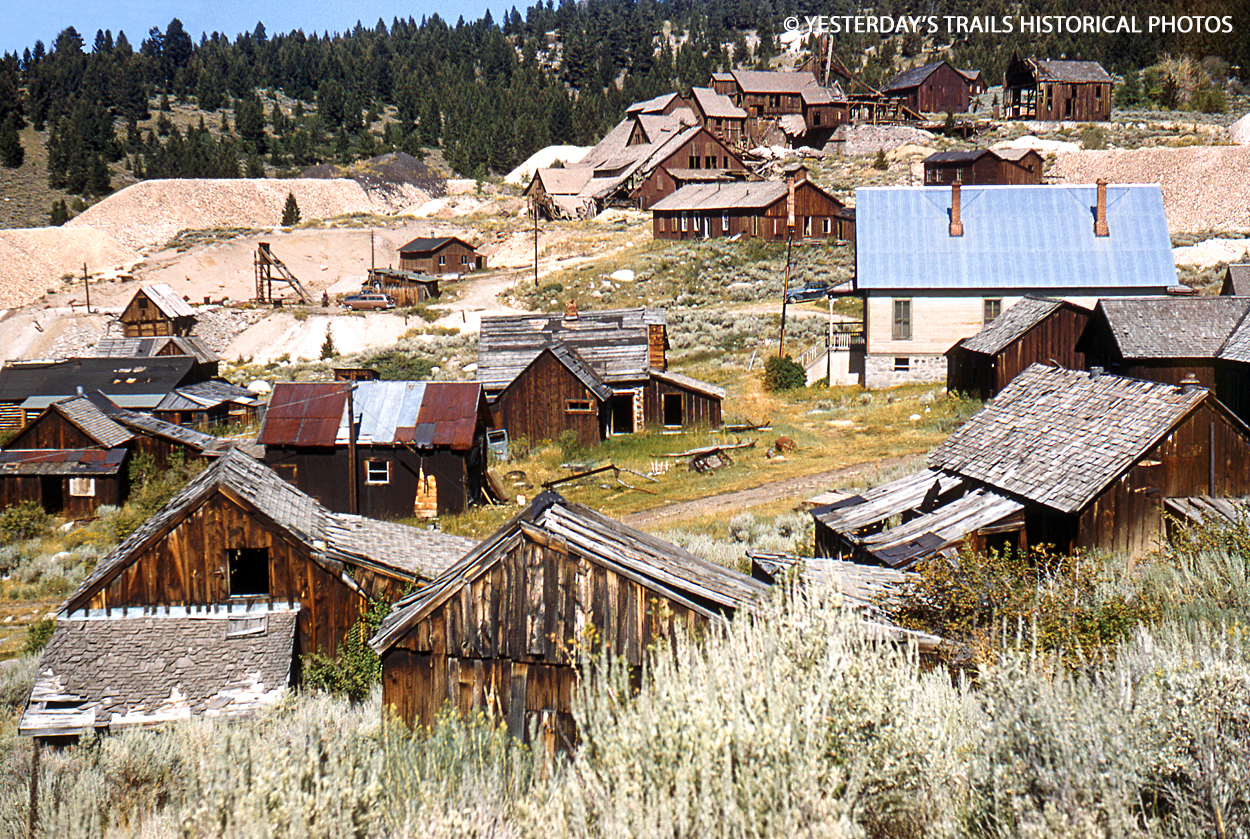
This is a restored view looking at abandoned buildings and the mine at the silver-mining ghost town of Elkhorn, Montana as seen in 1955.
The town was founded in 1872 after the discovery of silver deposits by Swiss prospector Peter Wyes in the hills above the town in 1870.
Unfortunately for him, he died mysteriously before he could make any meaningful fortune from his discovery. In 1875, Anton M. Holter, a rich miner bought the old Wyes claims and established the Holter Lode which was the first silver mine in Elkhorn.
The development of more mines around the Holter Lode brought in more miners and settlers leading to the creation of Elkhorn, a booming town that supplied the mines.
By 1882, the Holter Mine reached peak production & the town boasted a population of 2500 people. At it’s peak in the early 1890’s, Elkhorn had several retail stores, a post office, three hotels and numerous saloons lining the main street. There was also a school, boarding houses, hundreds of homes, a livery, several blacksmith shops, barbershops and a Methodist church.
Unlike many mining camps in the area, most of the residents of Elkhorn were European immigrants with families who relied not just on the mines but also established a thriving woodcutting business in the nearby forests.
Prosperity for all was maintained until the winter of 1888-1889, when a diphtheria epidemic raged through the camps & Elkhorn, killing many, including most of the children of Elkhorn. This was shortly thereafter followed by the sharp drop in the price of silver in 1892 following the decision by the government to drop silver as a monetary base. This marked the beginning of the end of mining in Elkhorn. Many mines closed down in the following few years.
Following the closing of mines in Elkhorn, many of the miners left. By 1893, the population of Elkhorn had dropped to about 600 people. In the following years, the railroad was discontinued, the post office was moved and the school was closed down. The railroad tracks were pulled up in 1931.
Elkhorn was chiefly abandoned in the 1970s, with only a handful of residents persisting into the 21st century. Today, the ghost town stands as Montana’s smallest state park, and what remains of Elkhorn is in varying states of preservation.